


- Home » News » Technology News

Contour-based navigation needs no markers

The German sensor-maker Sick has announced a contour-based navigation technology for mobile platforms such as AGVs (automated guided vehicles), carts, forklifts and service robots, that allows them to move freely around a factory and warehouse without needing reflectors or other physical markers. The Lidar-Loc (localisation on contour) system guides the vehicles using pre-mapped contours.
The system avoids the need to move fixed infrastructure to clear paths for AGVs, automated forklifts or shuttle systems. Applications using one or more Lidar (light detection and ranging) sensor can be set up with minimal programming time, and there is an option to integrate motion control and odometry. As a result, software development, installation, hardware and maintenance costs can all be cut dramatically, according to Sick.
The system can be retrofitted to already-installed scanners, and is available in a software-only option. It learns and recognises the physical contours of a factory or warehouse, thus avoiding the need to install and maintain reflectors, special paints, tracks, magnetic strips or coloured tapes.
Neil Sandhu, Sick’s product manager for imaging, measurement and ranging in the UK, says that the 2D Lidar application follows the success of the company’s “localisation on contour” algorithm which has been available on its 360-degree Nav scanners since early 2019.
“Many of our customers using Sick safety scanners on mobile platforms have been asking us if they can access the raw data for navigation purposes, so they can save cost, space and wiring complexity, especially for smaller and low-to-the-ground mobile platforms,” explains. “This is therefore an important step towards achieving greater Industry 4.0 production flexibility and Sick is the first manufacturer to offer an entire hardware and software solution as part of its indoor localisation portfolio.”
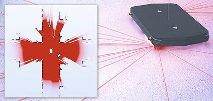
The Lidar-Loc software runs on Sick’s Sensor Integration Machine, allowing all of its LMS, TiM and Nav 2D Lidar sensors – as well as its safety scanners, such as the microScan3 – to be used for navigation, eliminating the need to install additional localisation sensors. Whether used in a new machine, or in an existing architecture, the set-up is “almost plug-and-play”.
As the vehicle is driven manually around its working environment, the on-board Lidar scanner learns prominent contour features, such as walls, static machines, racks and bays. This data is used to create a precise reference map which is stored on a SIM, ready for commissioning on-site. Set-up and operation are simplified by using a Web browser, and integrating the technology with robot operating systems.
The Lidar-Loc has a scanning angle of up to 360 degrees, a working range of up to 250m with precise contour recognition, a positioning accuracy of ±30mm, and a localisation resolution of 1mm at 30Hz refresh rates, depending on the scanner used.